Indexes:
About this entry:
- Updated 19 May 2013
- Updates planned: 1
|
Hithlum
The misty lands north of Beleriand
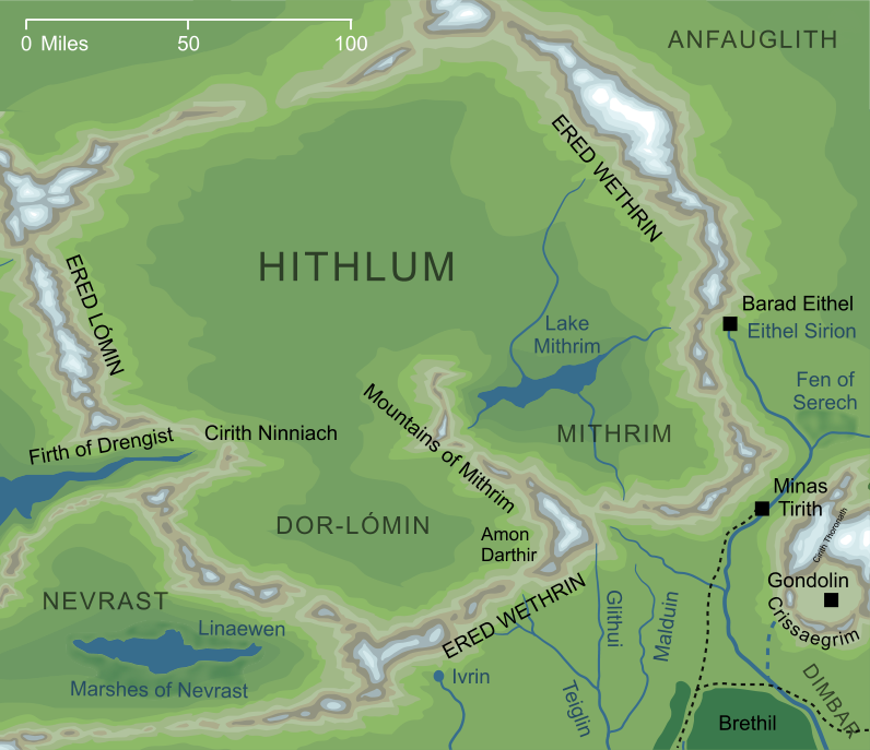
Map of Hithlum (slightly conjectural)1
Map of Hithlum (slightly conjectural)1
The misty, grey land held by Fingolfin and his people to the north of Beleriand, fenced by the mountain range of Ered Wethrin.
Notes
1 |
The map shown here is largely canonical, except for the ridge of hills that form Hithlum's northern border. The standard Silmarillion map does not show the extreme northern extent of this land, but a sketch map reproduced in volume XI of The History of Middle-earth shows a low range of hills running in the direction shown.
|
See also...
Aerin, Annon-in-Gelydh, Aradan, Aredhel Ar-Feiniel, Balrogs, Barad Eithel, Bëorians, Brodda, Dragonhead of the North, Echoing Hills, Echoing Mountains, Edain of the North, Eldar of Hithlum, Elu Thingol, Elves of Beleriand, [See the full list...]Elves of the Falas, Ered Lómin, Ered Wethrin, Falathrim, Fell Winter of the First Age, Fingolfin, Fingon, Gate of the Noldor, Gundor, Hísilómë, Horses, House of Fingolfin, Incomers, King of the North, Lake Mithrim, Land of Mist, Land of the Elves, Lorgan, Magor, Malach Aradan, Men of Hithlum, Morgoth, Mountains of Dor-lómin, Mountains of Mithrim, Mountains of Shadow, Rochallor, Shadowy Mountains, Shadowy Mountains, Swarthy Men, Three Houses of the Edain
Indexes:
About this entry:
- Updated 19 May 2013
- Updates planned: 1
For acknowledgements and references, see the Disclaimer & Bibliography page.
Original content © copyright Mark Fisher 1998, 2001, 2008, 2013. All rights reserved. For conditions of reuse, see the Site FAQ.
|