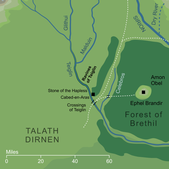
At a point roughly halfway along its length, the river Teiglin ran past the eaves of the Forest of Brethil, before it entered the southern parts of the forest and flowed on to meet Sirion. In this part of its course, the river cut a deep chasm with steep sides. The length of this ravine is unclear, but it ran for at least two miles2 past the Crossings of Teiglin. It was also extraordinarily narrow; at one point, known as Cabed-en-Aras, it was said to be narrow enough for a deer to leap from one side to the other.
The Ravines were important to the story of Túrin Turambar, for it was here that he slew the Dragon Glaurung. Making the treacherous climb down one side of the ravine and up the other, he was able to conceal himself beneath the lip as the great Dragon made his crossing. With a thrust of his sword Gurthang, Túrin gave the Dragon a mortal wound. Before his death, however, Glaurung revealed to Túrin's wife Níniel that she was in fact his sister Niënor, and in her despair she leapt to her death from the brink of the Ravines of Teiglin.
Notes
1 |
Though Beleriand was overwhelmed by the Great Sea at the end of the First Age, a few scattered highlands survived as islands. One of these was Tol Morwen, and that island was formed from the grave mound of Morwen and her children, which had originally stood on the brink of the Ravines. At least some part of the Ravines themselves, then, may also have survived to support this lone island.
|
2 |
The geographical specifics of the Ravines are not entirely clear. We know from Narn i Chín Húrin that they were visible from Dimrost on the road from the Crossings, and that they lay two miles to the west of that place. We also have a sketch map by Christopher Tolkien in Unfinished Tales that suggests that they carried on eastward of the Crossings and past the inflow of the stream Celebros. The considerations would make them over two miles long at a minimum, but they presumably extended somewhat further, perhaps as far upstream as the inflow of Teiglin's tributary Malduin, or even beyond.
|
Indexes:
About this entry:
- Updated 21 April 2016
- This entry is complete
For acknowledgements and references, see the Disclaimer & Bibliography page.
Original content © copyright Mark Fisher 2002, 2015-2016. All rights reserved. For conditions of reuse, see the Site FAQ.