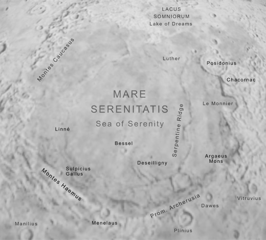
| Feature on | The Moon | | Feature type | Mare (Lunar sea) | | Quadrangles | Primarily LQ-12, but extending into LQ-05 | | Lunar coordinates | 16 - 38° N, 7 - 30° E | | Dimensions | Diameter 674 km; area c.318,000 sq km | | Bounding features | Montes Caucasus, Montes Haemus | | Interior features | Banting, Bessel, Brackett, Deseilligny, Hornsby, Linné, Luther, Menelaus, Posidonius N, Sarabhai, Sulpicius Gallus |
The Sea of Serenity forms a large and prominent near-circular feature in the northern part of the Moon's nearside face.
A prominent sea in the northern hemisphere of the Moon. Though it is by no means the largest of the Moon's maria, its distinct circular shape marks it one of the most prominent seas on the Moon's nearside face. In renderings of the 'Man in the Moon' the Sea of Serenity typically forms the left eye.
Mare Serenitatis falls between Mare Imbrium or the Sea of Rains to the west, and Mare Tranquillitatis (the Sea of Tranquility) to the southeast. The entire sea comprises a field of nearly featureless and flat basalt covering an area of some 318,000 square kilometres (making it a little smaller in area than the Caspian Sea on Earth).
Boundaries
On the western side of the sea, its basalt surface blends somewhat with the surface of the Mare Imbrium, with the two seas being separated by an irregular range of peaks known as the Montes Caucasus. To the north, Mare Serenitatis is bounded by a range of rough highlands that reach an end near its northeastern extent, where the sea breaks out into a small 'lake', Lacus Somniorum or the Lake of Dreams. At the southern extent of the sea's border with this lake lies the walled plain Posidonius.
Southward along the eastern edge of the sea, beyond Posidonius, is a mountainous region visited by several exploratory missions from Earth. The Lunokhod 2 rover explored the crater le Monnier a little to the south of Posidonius, and some kilometres further south still is the landing site of Apollo 17 among the Taurus Mountains.
The southeastern extent of the Sea of Serenity is marked by the peak of Argaeus Mons, and moving westward from this mountain its southern border is marked by a jumble of low-lying land and lunar rilles. At its southern point is promontory, Promontorium Archerusia, and from there the boundary is marked by higher land: a range of mountains known as Montes Haemus runs along its southwestern and western edge to meet Montes Caucasus and complete the circuit of the sea's boundaries.
Interior
The eastern and southern parts of the Sea of Serenity are marked by a collection of ridges, of which the most prominent is the Serpentine Ridge, meandering across the landscape from north to south in the sea's southeastern quarter.
Other than the Serpentine Ridge, the interior surface of the Mare Serenitatis is not notable for significant features. The largest crater at least partially within its boundaries is the twenty-seven-kilometre-diameter Menelaus, which extends out from the southern shores of the sea into the highlands beyond. Of craters entirely within the mare, the largest are Bessel (sixteen kilometres in diameter), and Sulpicius Gallus (twelve kilometres in diameter) near the foothills of Montes Haemus near the sea's southwestern edge. The surface is dotted by a handful of smaller craters (including Banting, Deseilligny, Hornsby, Linné, Luther and Sarabhai) but none of these exceed a diameter of ten kilometres.
|
|