The Encyclopedia of Arda - an interactive guide to the world of J.R.R. Tolkien
Dates
Constructed in the late Second Age1
Location
Running through the White Mountains from Nardol2 to Amon Dîn
Origins
Created by the Gondorians early in their kingdom's history
Race
Division
Culture
Important peaks
Ran from Nardol in the west to Amon Dîn in the east, passing to the south of Eilenach
Meaning
Wain is an old word for 'wagon' or 'cart'; the valley was made for the passage of wagons hauling stone
Other names
Said to be a translation of Elvish Imrath Gondraich

Indexes:

About this entry:

  • Updated 20 September 2019
  • Updates planned: 1

Stonewain Valley

The ancient way of the quarrymen of Gondor

Map of the Stonewain Valley

A long straight valley in the eastern White Mountains. It was made in ancient days by the Men of Gondor, as a route from the quarries beneath Nardol to Minas Anor. By the time of the War of the Ring, it was forgotten by all but the Woses of the Drúadan Forest, who revealed it to the Rohirrim so that they could come to the aid of Gondor in the Battle of the Pelennor.


Notes

1

The great cities of Gondor were established in the late Second Age, and the purpose of the Stonewain Valley was to carry stone for their building, so it was clearly made very early in Gondor's history. This would date it to II 3320 or shortly afterward. By the end of the Third Age it had been generally forgotten, having fallen out of use many generations beforehand. It was not forgotten by the Drúedain, however, and thus the Rohirrim were able to ride along it to the defence of Minas Tirith on 14 March III 3019.

2

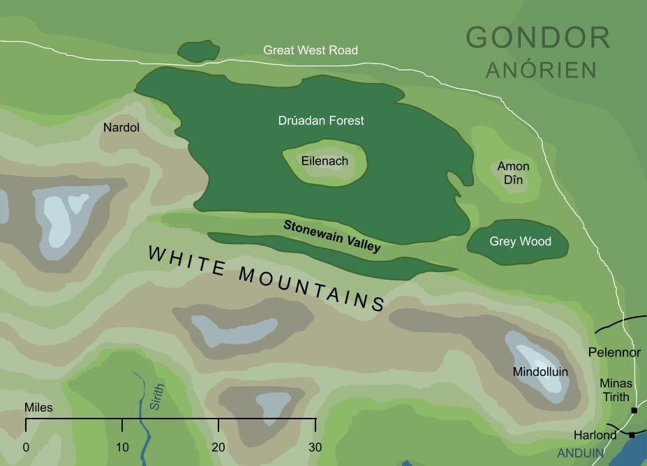
Actually, the valley seems to have started some distance eastward from the peak of Nardol, but it could still be said to begin on the mountain's wide eastward slopes (hence its description as running 'from Nardol to Dîn' in The Return of the King V 5, The Ride of the Rohirrim). This course took it southward of the Eilenach Beacon and the Drúadan Forest, emerging somewhat southward of Amon Dîn.

All our references, both text and maps, agree on this general geography, with a single awkward exception. Earlier in the chapter referenced above, Ghân-buri-Ghân twice describes the Stonewain Valley as starting near Min-Rimmon. For instance, he describes it as being '...there behind Rimmon' (ibid). This is odd, as Ghân was speaking in the Drúadan Forest and describing a mountain some eighty miles to the west. In early drafts the name 'Min-Rimmon' was used for the Beacon-hill later called 'Eilenach', and the retention of 'Rimmon' here seems to be an editorial oversight. That is, when references to 'Min-Rimmon' were changed to 'Eilenach', this paragraph was apparently overlooked.

It is, however, conceivable that Tolkien really did intend that the valley ran on westward as far as distant Min-Rimmon. On balance, this seems unlikely, but there is sufficient room for doubt about the intended meaning that the original text is retained even in the latest editions of The Lord of the Rings.

Indexes:

About this entry:

  • Updated 20 September 2019
  • Updates planned: 1

For acknowledgements and references, see the Disclaimer & Bibliography page.

Original content © copyright Mark Fisher 2000, 2019. All rights reserved. For conditions of reuse, see the Site FAQ.

Website services kindly sponsored by Your Free Personality Test, the free personality test online
Get real insights into who you are. Try a free personality test from Your Free Personality Test today.
The Encyclopedia of Arda
Menu
Homepage Search Latest Entries and Updates Random Entry