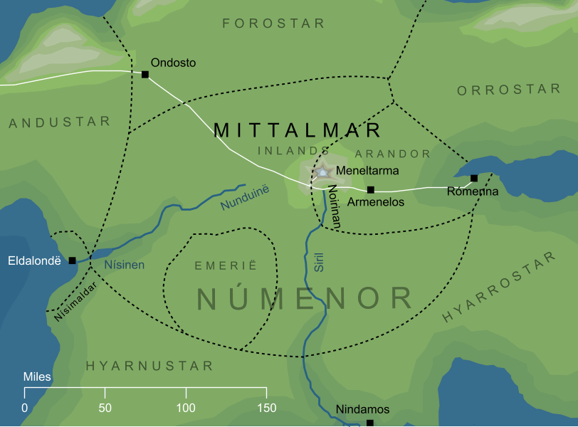
A pastoral region of grassland and pasture that lay in the central parts of the island of Númenor. The borders of the Mittalmar formed a roughly oval region, two hundred and fifty miles west to east, and one hundred and seventy north to south. Near its centre rose a single tall mountain, the famous Meneltarma, the Pillar of Heaven. The two main rivers of Númenor had their springs in this region, the Nunduinë that flowed westward, and the Siril that flowed south.
The eastern part of the Mittalmar was the most important region on the whole island. This was Arandor, the Kingsland, where the royal city of Armenelos stood, as well as the bustling eastern port of Rómenna. A road ran between these two cities, and carried on westward across the Mittalmar and into the western parts of the island.
Notes
1
The name Mittalmar is conventionally translated as the 'Inlands' of Númenor, but the derivation of the name is not fully understood. It seems to contain mitta ('within', 'between') and probably also mar ('home', 'dwelling-place'), so a more literal translation would be something like 'inner homeland'. The name was conceivably influenced by talmar, 'roots', due to the presence in this region of the Tarmasundar, five ridges that formed the Roots of the Pillar of Heaven.
2
The geography shown here largely follows the canonical map of Númenor, with a single exception: the city of Ondosto is not shown on that map. Given the relevant textual descriptions, Ondosto must have stood close to the point shown here, but may not have been at that precise location.