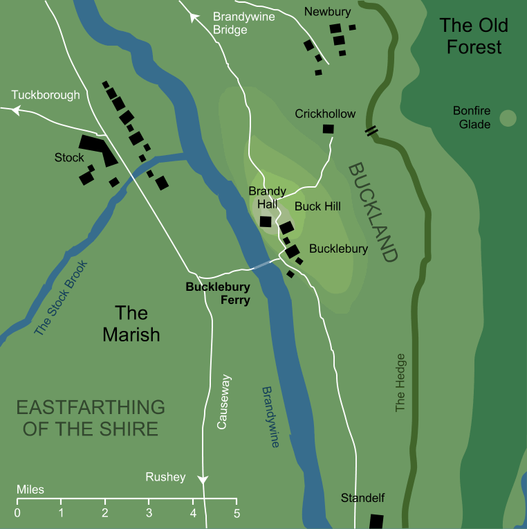
A ferry crossing on the wide river Brandywine, connecting the Marish region of the Shire's Eastfarthing with Buckland across the river. On the Buckland side of the river (that is, the eastern bank) the ferry docked at a platform serving the town of Bucklebury beneath Buck Hill, and from this the ferry took its name. This eastern Bucklebury landing lay beneath a steep stretch of river bank, and a winding pathway climbed up the bank from the dock into the township itself.
On the opposite bank to the west, there was no village or settlement of any kind.2 The ferry docked at a simple landing platform reaching out into the river, lit by a pair of burning torches. From this platform, a neat path ran westwards, lined with whitewashed stones. The lane ran for about a hundred yards before it reached the main Causeway through the Marish, at a point about halfway between Stock to the north and Rushey to the south, where it was marked by two white posts.
The ferry boat itself was large and flat, propelled through the water by a long pole.3 There was no ferryman (at least, none is recorded); rather, passengers would sail the ferry themselves from one side of the river to the other.4
Bucklebury Ferry played a small but important part in the War of the Ring. Before Frodo Baggins began his fateful journey from Bag End, his friend Meriadoc Brandybuck had set out by cart to transport Frodo's belongings to the his new house in Buckland. He then rode a pony back from the house at Crickhollow down to Bucklebury, and rafted across the Brandywine aboard the ferry. Thus Frodo and his party found the ferry waiting for them at the landing stage on the western bank.
The Hobbits crossed the River, but it was only when they reached the other side that they realised how close they had come to disaster. On the western bank - the bank from which they had just departed - they saw the dark figure of a Black Rider. With the ferry now docked on the eastern bank, and no other means of crossing within twenty miles, the pursuing Rider was foiled and the Hobbits were able to follow their plan to slip secretly out of the Shire.
Notes
1 |
The map shown here follows the detailed map of the Shire in The Lord of the Rings. Based on that source, the lane from the Causeway to the ferry's western mooring appears to run for about a mile. In fact, according to the text, this lane was only a hundred yards long, and seems to have been lengthened on the map for the sake of clarity.
|
2 |
The fact that the ferry's western landing was miles from the nearest village, whereas on the east bank it landed directly at the village of Bucklebury, implies that it was made for the convenience of the Bucklanders rather than the Shire-hobbits. We could take it from this that it was established by the Hobbits of Buckland to make westward journeys into the Shire, though clearly the ferry could be used in either direction as needed.
|
3 |
In the original texts of The Lord of the Rings, the ferry was propelled by simple oars. In a later illustration of the ferry, Tolkien drew it being driven by a pole, and the text of the book was later revised to correspond with that drawing.
|
4 |
Actually, our understanding of how the ferry worked is rather limited, as we only have a description of its use in the dark of night, and it is possible that the ferry was attended during daylight hours. Indeed, it is difficult to see how a traveller on the western bank could cross the river otherwise (the ferry seems to have been conventionally docked on the eastern bank, beneath Bucklebury, when not in use).
|
Indexes:
About this entry:
- Updated 30 October 2019
- This entry is complete
For acknowledgements and references, see the Disclaimer & Bibliography page.
Original content © copyright Mark Fisher 1998, 2001, 2007, 2017, 2019. All rights reserved. For conditions of reuse, see the Site FAQ.
Website services kindly sponsored by myDISCprofile, the free online personality test.
Explore the benefits of using a personality profile to discover yourself and make the most of your career.