The Ash Mountains of northern
Mordor (slightly conjectural)
1
The Ash Mountains of northern
Mordor (slightly conjectural)
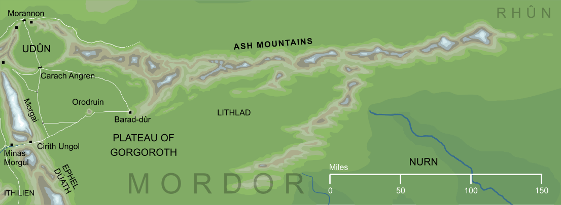
1A range of grey, mist-shrouded mountains that ran out of the eastern lands almost directly westward for more than two hundred miles to form the northern border of the land of the Mordor. The ridged and broken landscape of the range was the grey colour of ash, from which they took their Elvish name Ered Lithui,2 variously translated as the Ash or Ashen Mountains.
From the southern side of the main range, spurs of rock extended out into the deserts of northern Mordor. Between the two longest of these rocky spurs, running along the central third of the range, was a wide lowland known as Lithlad, the plain of ash. The westernmost major spur, forming Lithlad's western edge, extended into the Plateau of Gorgoroth and angled toward Orodruin. It was on the end of this rocky outcropping that Sauron chose to build his Dark Tower of Barad-dûr.
At their western end, the Ash Mountains divided into two arms, thrusting out to form the wide flat-bottomed valley of Udûn. It was here that the mountains met the range of the Mountains of Shadow, Ephel Dúath running northward along Mordor's western border. In the far northwest of the land, the two ranges came together to form the narrow Haunted Pass of Cirith Gorgor. Here Sauron built a vast Black Gate, the Morannon, to guard the main northern entrance to his Dark Land. Some miles to the south, at the other end of the road through Udûn, the second western arm of the Ash Mountains also came close to a spur of the Mountains of Shadow, forming an inner guarded pass into Mordor known as Carach Angren.
From the Morannon at the range's western extent, a road had been made3 that skirted the northern foothills of the Ash Mountains for at least fifty miles. After Sauron was defeated at the end of the Second Age, the Gondorians kept this road in repair as part of their guard on Sauron's old strongholds. Eventually their watch failed, and the road was used instead by enemies of Gondor coming out of the East, because it allowed easy travel while the geography of the mountains hid approaching armies from watchers in the west.4
Most notable among these Easterling attackers were the Wainriders in III 1944, who followed the line of the Ash Mountains with a great force. The road along the mountains allowed them to approach Gondor with stealth and with remarkable speed. They were met by King Ondoher, whose death in the ensuing battle caused a crisis in Gondor. The Wainriders were ultimately defeated at the Battle of the Camp, and the victorious Gondorian general Eärnil eventually succeeded Ondoher as King of Gondor.
The same tactic was used during the War of the Ring more than a thousand years later, when the Captains of the West parleyed with the Mouth of Sauron at the Black Gate. After this parley failed, the Morannon was opened and Orcs emerged, but an army of Easterlings also suddenly appeared. These had been standing ready beneath the northern Ash Mountains, concealed from the Captains of the West by the formation of rocks around the Gate, so that they could join the battle without warning. (In the event this tactic proved fruitless, as the destruction of the Ring brought about the defeat of Sauron and his armies.)
Notes
1 |
The road running eastward along the northern edge of the Ash Mountains from the Morannon is not shown on any canonical map. Its general course and its length are well described, however, so while the position shown may not be exactly correct, it must be relatively close to the actual line of the road. |
2 |
It seems natural to imagine that the Ash Mountains' name might have some relationship to the ash produced by the volcano of Orodruin, which lay close to the western end of the range. The name is, however, consistently explained as coming from the mountains' grey colour, and had no apparent connection with the ash of Orodruin. Perhaps this is also true of Lithlad, the plain of ash running along the mountains' southern edge; that is, the plain was presumably named for the mountain range it bordered (though in this case some connection to the literal ash of Orodruin might also have influenced the name). |
3 |
It is not said who made this road. On balance, it seems most likely that Sauron constructed it during the Second Age to ease the passage of his allies to the Morannon. Alternatively, given that the Gondorians used the road during the earlier Third Age as part of their guard on the realm of Mordor, it is at least conceivable that the Men of Gondor had made the road after Sauron's defeat in the War of the Last Alliance. |
4 |
Though the range ran generally east-to-west, it also bowed slightly southward. This meant that a watcher at the western end could not see along the line of the mountains, but would need to travel some miles eastward past the Morannon before the full line of the road became visible. |
Indexes:
About this entry:
- Updated 30 August 2020
- This entry is complete
For acknowledgements and references, see the Disclaimer & Bibliography page.
Original content © copyright Mark Fisher 1998, 2001, 2017-2018, 2020. All rights reserved. For conditions of reuse, see the Site FAQ.