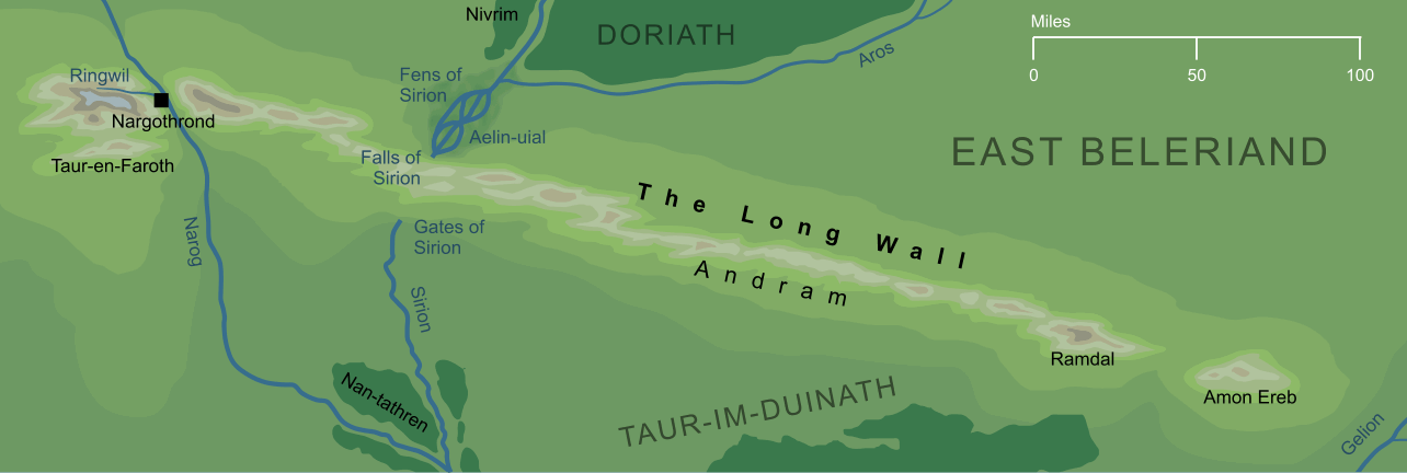
An escarpment that ran across much of Beleriand, separating the higher lands to the north from the lowlands to the south. This Long Wall (or Andram in Elvish) extended for some three hundred miles (or about 480 km) stretching from the river Narog in the west almost as far as the river Gelion in the east.
The far western extent of this long ridge formed the hills known as Taur-en-Faroth, the Hills of the Hunters that rose above Narog on its western bank. These hills stood apart from the rest of the Long Wall as the river Narog cut a gorge through the western end of the range, and it was within the caverns of this gorge that Finrod Felagund established his stronghold of Nargothrond.
From Nargothrond, the Long Wall ran on eastward until it came to another river, Sirion, but unlike Narog, Sirion did not cut through the hills. Instead it poured down great Falls on the northern side of the ridge, plunging underground and running beneath the earth until it emerged again, though the opening known as the Gates of Sirion, on the southern, lowland side of the Long Wall.
Beyond Sirion, the Long Wall continued eastward and a little southward until it approached a third river, Gelion, on the borders of Beleriand. It came to an end at the place known as Ramdal, 'Wall's End', but in fact the chain of hills carried on eastward beyond this point. After a stretch of lower land, a great hill rose up on the same line as the Long Wall, the lonely shallow-sided height of Amon Ereb. Southward of the heights of the Wall, between Sirion and Gelion, the lower lands of Beleriand were filled with a wide tangled forest. This dense Forest between the Rivers (Taur-im-Duinath) was almost uninhabited, other than by a few wandering Dark Elves.
The Long Wall played little direct role in the history of the Wars of Beleriand, though there were some minor incidents in the lands along its flanks. During the First Battle, fought under starlight even before the Noldor returned to Beleriand, a force of invading Orcs ventured into the lands of East Beleriand directly northward of the Long Wall. There they were intercepted by Thingol and Denethor, to be slaughtered or driven away northward. Centuries later, Elves fleeing the ruin of the Dagor Bragollach came to the Long Wall. These were led by Caranthir, Amrod and Amras, three of the Sons of Fëanor, who rounded the Wall's End at the eastern end of the Long Wall, and settled for a time on Amon Ereb.
After accounts of the Dagor Bragollach, the Long Wall faded entirely from history, and it must soon have come to an end altogether. Less than two centuries after the Dagor Bragollach, the War of Wrath would bring ruin on the lands of Beleriand, and the Long Wall of the Andram would be drowned beneath the waves of the Great Sea.
Indexes:
About this entry:
- Updated 2 September 2023
- This entry is complete
For acknowledgements and references, see the Disclaimer & Bibliography page.
Original content © copyright Mark Fisher 2002, 2008, 2020, 2023. All rights reserved. For conditions of reuse, see the Site FAQ.